WhiskyJack Publishing
  • Home
  • About
    • About Us
    • Our Life Here
    • First Lines-The Beardmore Relics
    • News Clips: Greenstone's Believe It or Not!
    • Q&A : Greenstone's Believe It or Not!
    • Tipping Points - GERALDTON BACK DOORS
    • The Jarheads of Goshen: Next to Last Lines
    • The Gardens of Goshen: Next to Last Lines
    • First Lines - GERALDTON BACK DOORS
    • Events
    • Blog Articles
  • Sample Chapters
    • Kennet Forbes Mysteries
    • The Chronicles of Goshen
  • Recent Titles
    • Retail Outlets
  • Book Credits
  • EJ's POSTS
  • Beardmore Viking Relics
  • Contact
    • Links
  • My Services
    • Description of Services
    • Pricing of Services

#26 - YE OLDE SCHOOL DAYS

11/11/2016

2 Comments

 
Picture
When I entered high school at age 13, I had not the faintest idea that history mattered.  The people that lived and events that happened before I was born, and when I was growing up, had a tremendous impact on my life, but I had no idea.  As we grow older, we all become historians.
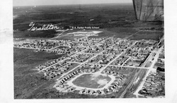
 I have never seen this photographic view before.  It is of personal interest because it shows the location of the high school, which I began attending as a Grade 9 student in September 1953, when I arrived in Geraldton. 

The high school building in 1953 was originally the public school, a one-storey structure of 4 classrooms.  By 1938, the board had added a second storey.  In 1940, the Town of Geraldton had appointed a high school board, which proceeded to construct  a one-storey building of 2 rooms immediately south of the public school, on the same grounds.  The new high school opened on September 3rd with 46 students, Grades 9 to 12.  When I started high school in 1953, this building was called "the annex"; it stood empty except when the girls used it for gym classes.

For September 1942, the high school board rented the Ukrainian Hall, a one-storey building which stood on the corner of Hogarth Ave. and First Street East.  It became the Junior High School.  It had two outdoor privies, and sometime later, chemical toilets.  Today it is a two-storey apartment block. 
By 1944, the high school board had to rent more space, this time in the T. Eaton Co. building (when I returned in 1970, this was the town office) on the corner of Hogarth Ave. and Main Street.  Both school boards began casting about for more classroom space.

In 1946, the school boards acquired two buildings from the Bankfield mine, no longer operating.  The smaller bunkhouse (28 by 56 feet) was relocated immediately north of the public school (as you see in the photo) and was named "the public school annex", having 2 classrooms (the original two-storey public school then had 8 classrooms).

The high school board relocated the two-storey bunkhouse (30 by 90 feet) next to the high school (see the photo), and its original one-storey building subsequently acquired the name "the high school annex" , , , 
I'm hoping some readers can share their memories of those old-time buildings now erased from the landscape.

Read the full post with photos on E.J. Lavoie's Blog >
http://bit.ly/2ei2pRQ

2 Comments

#25 - FROM GOLDFIELD TO JACKFISH 1

2/11/2016

1 Comment

 
Picture
Isn't that a marvelous title?  I have waited half a lifetime for an excuse to invent that title.  Ever since I saw the documentary film The Best Damn Fiddler from Calabogie to Kaladar. 

The latest incarnation of that title to inflict a rash of envy upon me is the TV series Lark Rise to Candleford.  Haven't watched a single episode yet, I am so green with jealousy.

So, enjoy the title of this post.  And read on, for you won't be disappointed.

In a single day I traveled from the snow-haunted woods of the world's second largest boreal forest to the shore of the world's largest and still unfrozen freshwater sea, and back again.  Wow wow wow.  I shall never forget it.

I was driving my faithful '97 Nissan Patfinder.  Yes, faithful.  I got the gas line break and the leak in the gas tank taken care of, and I would stake my life on that truck now.  Oftentimes I have.

I started at daybreak yesterday, after a centimetre of fresh snow had fallen overnight, adding to the two centimetres that had fallen a day or two before.  The Goldfield Road runs due south to the North Shore of Lake Superior, linking Hwys. 11 & 17, the two – the only two – cross-Canada road links through the boreal region.

The vehicle tracks in the freshly fallen snow told me I was not alone – that if my faithful truck broke down, I would be found within the next day or two.  Twenty minutes later, I was following only two tracks, the others having turned off.  Another twenty minutes, and I was following a single track.  Another forty minutes, and I was alone, breaking trail.  It started to snow.  Steadily.

I saw it up ahead, about three-quarters of a kilometre away on a straight stretch.  It was travelling on the northbound side of the Goldfield.  I figured at first it was human . . . [It turned out] I was looking at the largest black wolf I have ever seen . . .

ORIGINAL POST 18 November 2011 (first of 3 chapters)
Read the full post with colour photos on E.J. Lavoie's Blog > http://bit.ly/2feBvga


1 Comment

E.J.'s POST #24 - MAGIC HAPPENS

27/10/2016

1 Comment

 
Picture
Here in the boreal forest of Canada, winter is a-coming.  I got a taste of it last Monday, when Clarence and I were scouting a trail into the Kamuck River.

It was bitterly cold – no snow, just cold.  We were tramping around the bush in a remote location.  I knew I had issues with my truck, a '97 Nissan Pathfinder, for there was a leak at the top of the gas tank which I was prepared to live with.  You can sink only so much money into an old truck.  That meant I had to carry extra gas.  And in the past few months, I'd had problems with the battery discharging.  I'd brought along a power pack to address that issue.  Still, we were miles from nowhere, on a road no one would travel until next summer, and if the truck failed us, we might be camping out till spring.

Well, we finished our scout and climbed into the truck.  The gas gauge indicated close to empty, and the needle sank rapidly.  We stopped and poured in 20 litres.  That got us to the main road, the Goldfield.  The needle was still sinking, very rapidly indeed.  There was no traffic on the Goldfield, and we were still 50 klicks from the highway.  In another 10 klicks, the gauge read dead empty.

Clarence crawled under the truck and found the problem – a leaking gas line.  The fuel was pouring out . . .

ORIGINAL POST 13 November 2011

Read the full post with colour photo on E.J. Lavoie's Blog > http://bit.ly/2dKs8lJ

1 Comment

 EJ's POST #23 - COLLINGWOOD CAPERS (Chapter 1 of 3)

25/10/2016

1 Comment

 
Picture
1  ̶  BLUE MOUNTAIN
   Just the other day, I reached Collingwood by traveling on a paved road all the way from Greenstone.  Collingwood is a community of 19,500 on the shore of Georgian Bay, Lake Huron.  Then I took a paved road to The Big Stink, also spelled T-O-R-O-N-T-O. 
   One hundred forty-six years ago, Colonel Garnet Wolseley left Toronto to quell the Métis Resistance in Red River, North-West Territories.  He and 1,200 armed men travelled by rail to Collingwood to embark on steamers bound for Prince Arthur's Landing on the west shore of Lake Superior.  They wanted to arrest one man, or hang him, whichever came first.
  My sister, Grace, lives in Collingwood.  She has retired there.  She doesn't remember Col. Wolsely, but she has never forgotten the magnificent ski runs that attracted her to Collingwood many decades ago.  The historical record shows that Wolseley was not interested in the skiing.
  I, on the other hand, have long been interested in Col. Wolseley.  And when I saw those ski runs, well . . . wow.  But, a country boy like me is easily impressed.
  Going to and from T.O. (The Big Stink), I spent a few hours in the Georgian Triangle, not to be confused with the Bermuda Triangle.  In the G.T., people mysteriously disappear for just a few hours.  Because.  There is just so much to see and do.  Bear with me as I roam through orchards of country, culture, and history.
  By the way, the G.T. offers orchards for over 30 different species of apple, including its signature Honeycrisp.  And I never got to taste one.  So much to see and do.
  When I arrived on Sunday, September 18, Grace whisked me away to The Spit (more on that later), the interminable shoreline of Georgian Bay, and the Wasaga Blues Festival (more on that later).
  Monday morning, she introduced me to Blue Mountain.  The mountain, as it happens, is green, not blue.  It is a section of the Niagara Escarpment, probably the predominant geological feature of all of Eastern Ontario, let alone of the Collingwood country.  The Escarpment begins in the east in New York State, allows five of the six Great Lakes to cascade over its lip at Niagara Falls, and extends westward to the Illinois-Wisconsin border.  And there it sat on Monday morning, smiling greenly on the city, and gazing out fondly over the great inland sea. 
  When we zipped along the foot of the mountain, I fairly gasped . . .
 
Read the full post with photos on E.J. Lavoie's Blog > http://bit.ly/2eiPj7V


1 Comment

#22 - A WRITER'S GOTTA DO WHAT A WRITER'S GOTTA DO

17/10/2016

1 Comment

 
Picture
What possesses a couple of writers to venture into wave-swept waters in a tiny canoe in November?
            Well, why don't you ask me?  That's what I did yesterday, with my companion Clarence.
            Yesterday might have been the last day of summer.  The first snowfall had melted.  The temperature had risen above zero.  No ice on the lake yet.  And the wind gusts reached velocities of less than a hundred klicks an hour.
            You see, I am preparing Muskeg Tours 2012 for publication.  In 1987, I published the original text about the historic sites of the LIttle Long Lac Gold Camp.  In that year I visited all the sites, took pictures, described the scenes.  Soon I will publish a completely updated version.  For the past year I've had only one more site to visit – well, re-visit.  The Elmos mine.
            Tom Johnson, prospector, was the father of this mining camp.  It was Johnson who, in 1932, discovered the Little Long Lac mine on the south shore of Barton Bay, the west arm of Kenogamisis Lake.  A railway ran about a mile-and-a-half north of the bay, and that was the only link to civilized Canada.  There wasn't a single road in the region closer than a hundred miles.  While he was waiting for a big-shot investor to arrive by plane, he explored a little further west down the bay.  That's when he made the strike that would become the Elmos mine.
            Okay, you have a question.  Why has it taken me a year to get to the site?  Well, it is out of the way.  It never had a road to it.  It was served by a wooden trestle that bridged a smaller bay back in the '30s.  That trestle rotted away long ago.  It is accessible now only by water.  And I did try once last year – lined up a boat, and just as we were about to launch, my partner and I chickened out.  The waves were formidable. 
            And then, you know how it is.  One thing after another that claimed my attention, including writing my debut novel and getting it launched.  So that's my story, and I'm sticking to it.
            A few days ago I put my canoe in the water and made another attempt by myself.  Again, driven back by the west wind and waves.
            So yesterday, I enlisted another partner, and though it was still windy, we bucked the waves successfully.  Only swamped once . . .
ORIGINAL  POST 6 NOVEMBER 2011
Read the full post with photos on E.J. Lavoie's Blog > http://bit.ly/2dlCqvn

1 Comment

#21 - CHASING HISTORY

17/10/2016

0 Comments

 
Picture

0 Comments

#20 - OLD LOGGING DAM

27/9/2016

1 Comment

 
Picture

1 Comment

#19 - EXTREME HISTORICAL EVENTS

27/9/2016

1 Comment

 
Picture
If a tree falls in the forest and there is no one there to hear it, does it make a sound?

The answer is yes.

If a tsunami sweeps across an inland lake in the boreal forest, and there is no one there to see it, did it happen?

Maybe.

It depends on the track it leaves.

I have paddled across a big lake in a storm, in the teeth of a gale, for a solid two hours, non-stop, because if I stopped, I was dead.  When I finally looked back, there was no track.  It might have never happened.

Lake Nipigon is one of Canada's biggest lakes.  I have canoed it, but . . . never in a storm.  I was caught in a storm there once, and, apparently, I lived.

If I'd been out paddling a couple weeks ago, I would have, apparently, died.
In this neck of the woods, they call a tsunami a seiche (pronounced SAY –sh).  A strong westerly wind piled the water into a ridge and sent it rippling across the broad expanse of Lake Nipigon into the southeast arm, where the steep hills and narrowing corridor exacerbated the phenomenon.
I know it happened because I saw its track, two weeks later.

In September of 2009, my friend Peter took me sailing up the arm and into the open lake.  I was researching the shoreline for my novel, The Beardmore Relics.  It was breezy, but pleasant.  And we returned safely, apparently, to the dock.

That dock is no longer there . . .

ORIGINAL POST June 2011

Read the full post with colour photos on E.J. Lavoie's Blog > http://bit.ly/2cCrgB0


1 Comment

#18 - GROUNDED IN PLACE : FOLLOW-UP

14/9/2016

0 Comments

 
Picture
I am constantly amazed by my friends and neighbours because so many are so unfamiliar with their backyards.  I could place a bet that 90% of them could not locate the Kamuck River on a map without serious help.  Probably 80% have never visited Poplar Lodge Park.  Probably 70% could not name the Pallisades of the Pijitawabik, although they pass them every time they go to Thunder Bay.

I’m not faulting them.  I’m just stating a fact about people in general – we are almost oblivious to our surroundings.  We have to teach ourselves to be aware, and I include me in that “we”.
So last night on The National, when Peter Mansbridge flirted on air with Claire Martin, as per usual, maybe she was a little flustered.  Claire is Senior Meteorologist for the CBC.  I really enjoy her two-minutes of fame every weekday evening.  She was pointing out that Northern Ontario would be assaulted, for the third night in a row, by an overnight frost.  And the coolest community (in a temperature sense only) would be Armstrong.

Armstrong.  Guaranteed that 95% of my friends and neighbours have heard of the place – they know it is somewhere west of us.  On the west side of Lake Nipigon.  Ninety-nine point nine per cent of them have never been there, and have no immediate plans to visit.

Claire pointed out its location for the benefit of 99.99% of TROC (the rest of Canada).  She located it between Timmins and North Bay, a long, long way east of us, close to the Quebec border.

Claire, I forgive you, and millions of your fans will too. 

And Peter, shame on you.  Let the poor woman do her job.

ORIGINALLY POSTED 27 MAY 2011
Read other posts with colour images on E.J. Lavoie's Blog > http://bit.ly/1oXc9jS

0 Comments

#17 - GROUNDED IN PLACE

8/9/2016

0 Comments

 
Picture
ORIGINAL POST ON 26 MAY 2011
Decades ago, I read The Strange One by Fred Bodsworth.  The story is set in Northeastern Ontario, between Timmins and Moosonee, and one of the characters is a barnacle goose.

This goose resembles a Canada goose, but it is native to Europe.  In the story the barnacle goose is driven off its migratory route by storms and ends up at the bottom of James Bay.  There it links up with a flock of Canada geese.  In the flock, it is “the strange one”.  In the story a Native girl from James Bay leaves her community to educate herself in “Canada”.  When I taught in Moose Factory 50 years ago, the community joke was that anyone taking the train to Cochrane was “going to Canada”.
In “Canada”, the girl finds herself regarded as “the strange one”.

Okay, this is not about the goose or the girl.  This is a meditation on place – on its vital function in a story.

I was so enamoured of Bodsworth’s description of the natural home of the barnacle goose, in the Outer Hebrides of Scotland, that when I had an opportunity, I checked it out.

Yes, I went searching for the stretch of seashore described on the island of Barra in the Outer Hebrides . . .

Read the full post with colour photo on E.J. Lavoie's Blog > http://bit.ly/2bxZWlp


0 Comments
<<Previous

    Author

    E.J. Lavoie contributes a weekly column to Greenstone's Coffee Talk and the Nipigon-Red Rock Gazette.  The column can be read in its entirety on his blog, complete with images.  Just click the link at the end of each post.

    Archives

    November 2016
    October 2016
    September 2016
    August 2016
    July 2016
    June 2016
    May 2016

    Categories

    All

    RSS Feed

Powered by Create your own unique website with customizable templates.